


Descrizione di Guru Maps - Offline Maps & Navigation
Detailed and easy to use offline maps. We have millions POI on our maps. Record your GPS tracks and bookmark your favorite locations.
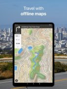
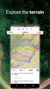
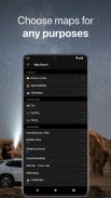
OFFLINE MAPS
• Amazingly detailed maps of all countries of the world.
• Based on open data from OpenStreetMap project. OSM is an open-source alternative to commercial navigation apps.
• Updated monthly with improved data.
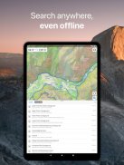
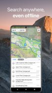
OFFLINE SEARCH
• Incredible fast – results appear instantly as you type.
• It works in a variety of ways – by object name, category or even by GPS coordinates.
• It finds objects in multiple languages – this will make your searching much easier than ever.
NAVIGATION
• Turn-by-turn driving directions.
• Voice instructions while navigating available in 9 languages.
• Routes for Driving/Cycling/Walking/Shortest Distance.
• Automatic rerouting gets you back along your way.
• Supports intermediate points on your itinerary.
$ SYNCHRONIZATION $
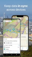
• Sync your data across multiple devices.
• Keep your data synced across Android and iOS platforms.
• It saves data on a server as a backup.
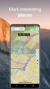
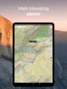
$ BOOKMARKS $
• Save favorite places on your map.
• Choose from lots of icons to assign to bookmarks.
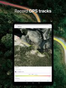
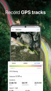
$ GPS TRACKS $
• Record your trips even when the app is in the background.
• Monitor your real-time speed, distance and time traveled, as well as altitude right on the map during the trip.
• Choose from 7 solid track colors or altitude and speed gradients.
$ IMPORT AND EXPORT $
• It's easy to export your tracks, bookmarks or whole travel collection as KML or GPX file.
• User itinerary is organized into collections for easy access.
SMALL FEATURES
• MBTiles and sqlitedb offline raster maps support.
• One finger zooming.
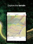
• Trip computer with speed and altitude.
• Tracking mode.
• Coordinates and scale.
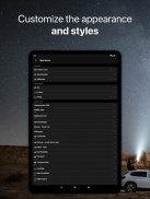
• Visible object set could be customized.
• 11 different map languages are supported.
• Map labels size could be changed. Large labels on maps are extremely useful while driving.
MAPS
Going on vacation? Don't forget to download an offline map with you. Rome, Italy? Just 16Mb. Paris, France? Just 67Mb. Barcelona, Spain? 197Mb. Amsterdam, Netherlands? 261Mb. London, UK? 283Mb. New York, Chicago, Florida, Las Vegas, Nevada, Seattle, San Francisco, California, USA? 500Mb in total.
Continued use of GPS running in the background can dramatically decrease battery life.
Mappe offline dettagliate e facili da usare. Abbiamo milioni di POI sulle nostre mappe. Registra le tue tracce GPS e aggiungi ai preferiti le tue posizioni preferite.
MAPPE OFFLINE
• Mappe incredibilmente dettagliate di tutti i paesi del mondo.
• Basato su dati aperti dal progetto OpenStreetMap. OSM è un'alternativa open source alle app di navigazione commerciale.
• Aggiornato mensilmente con dati migliorati.
RICERCA OFFLINE
• Incredibilmente veloce: i risultati vengono visualizzati immediatamente durante la digitazione.
• Funziona in vari modi: per nome dell'oggetto, categoria o persino per coordinate GPS.
• Trova oggetti in più lingue - questo renderà la tua ricerca molto più semplice che mai.
Navigazione
• Indicazioni stradali passo-passo.
• Istruzioni vocali durante la navigazione disponibili in 9 lingue.
• Percorsi per guida / ciclismo / camminata / distanza più breve.
• Il reindirizzamento automatico ti riporta lungo la strada.
• Supporta punti intermedi sul tuo itinerario.
$ SINCRONIZZAZIONE $
• Sincronizza i tuoi dati su più dispositivi.
• Mantieni i tuoi dati sincronizzati su piattaforme Android e iOS.
• Salva i dati su un server come backup.
$ BOOKMARKS $
• Salva i luoghi preferiti sulla tua mappa.
• Scegli tra molte icone da assegnare ai segnalibri.
$ GPS TRACKS $
• Registra i tuoi viaggi anche quando l'app è in background.
• Monitora la velocità in tempo reale, la distanza e il tempo percorso, nonché l'altitudine direttamente sulla mappa durante il viaggio.
• Scegli tra 7 colori di tracciati solidi o gradienti di altitudine e velocità.
$ IMPORT AND EXPORT $
• È facile esportare le tracce, i segnalibri o l'intera raccolta di viaggi come file KML o GPX.
• L'itinerario dell'utente è organizzato in raccolte per un facile accesso.
PICCOLE CARATTERISTICHE
• Supporto MBTiles e sqlitedb mappe raster offline.
• Zoom con un dito.
• Computer di bordo con velocità e altitudine.
• Modalità di monitoraggio.
• Coordinate e scala.
• Il set di oggetti visibili può essere personalizzato.
• Sono supportate 11 lingue di mappe diverse.
• Le dimensioni delle etichette delle mappe potrebbero essere modificate. Le etichette di grandi dimensioni sulle mappe sono estremamente utili durante la guida.
MAPPE
Andare in vacanza? Non dimenticare di scaricare una mappa offline con te. Roma, Italia? Solo 16 Mb. Parigi, Francia? Solo 67 Mb. Barcellona, Spagna? 197Mb. Amsterdam, Olanda? 261Mb. Londra, Regno Unito? 283Mb. New York, Chicago, Florida, Las Vegas, Nevada, Seattle, San Francisco, California, USA? 500 Mb in totale.
L'uso continuato del GPS in background può ridurre drasticamente la durata della batteria.
Guru Maps - Offline Maps & Navigation - Versione 5.5.1
(18-02-2024)
Guru Maps - Offline Maps & Navigation - Informazioni APK
Versione APK: 5.5.1Pacchetto: com.bodunov.galileoUltima versione di Guru Maps - Offline Maps & Navigation
App nella stessa categoria
Potrebbe piacerti anche...


